
New Orleans Reforestation Plan
Project Overview
New Orleans is known for its trees; majestic Live Oaks, towering Cypress trees, and flowering Magnolias line the streets to form the urban aesthetic that makes New Orleans unique. However, the trees in New Orleans are disappearing, and they are not being replaced at the rate of loss. Over 200,000 trees were lost in the aftermath of Hurricane Katrina, and more continue to be lost with each passing hurricane. The canopy still has never recovered.
A healthy urban forest can mitigate the impacts of the challenges facing the city. Providing cooler temperatures, storm resiliency, and urban beautification to promote safer and healthier communities, trees offer a number of benefits that directly improve the lives of New Orleanians. Unlike other Reforestation Plans that focus on an overall canopy percentage goal, this plan focuses on planting trees where communities need them the most. GIS data was used to analyze environmental and social factors to inform when and where tree planting would produce the greatest community benefit.
My Role
I led the GIS analysis and mapping for the New Orleans Reforestation Plan, transforming spatial data into actionable insights that informed design and planning decisions. Using geospatial datasets provided by Quantum Spatial and CASA Systems, I conducted geoanalysis using tools such as Zonal Statistics and the Spatial Analyst toolset to assess existing tree canopy coverage and identify areas with the greatest potential for reforestation. These maps and analyses supported the development of strategies aimed at increasing urban tree canopy, promoting equity, and enhancing resilience in neighborhoods most vulnerable to environmental risks. Through this work, I helped translate raw data into meaningful visuals and spatial narratives that guided policy recommendations.
Full report available at: https://soulnola.org/reforestationplan/
2023 ASLA Honor Award | Analysis and Planning: https://www.asla.org/2023awards/7466.html
This project was completed during my time at SMM

Analyzing the Environmental and Social Context: Synthesizing socio-economic and environmental data created a clear call to action around the need to center equity as a focus for the Plan.

New Orleans significantly trails other cities in canopy coverage and ranks as average for policies that protect and promote a healthy urban forest.

Three interdependent citywide goals were established based on the community aspirations and an assessment of the challenges facing New Orleans.

Benefits of trees are not equitably spread across the city. Low canopy coverage often correlates with extreme heat and a higher public health burden.

A 5-year Pilot Plan restores 10% tree canopy in five neighborhoods across the city, each chosen for their current tree deficit and environmental needs.
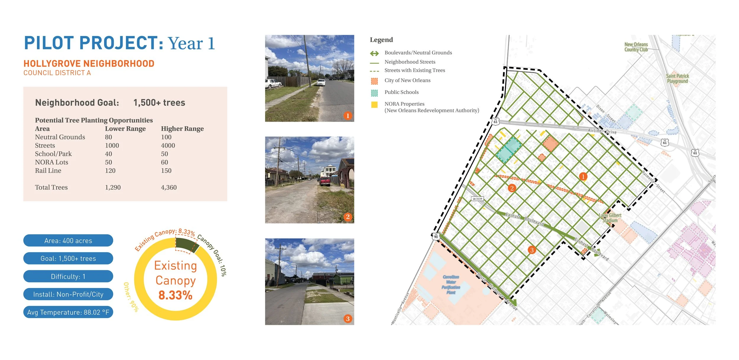
Hollygrove is proposed for Year 1 of the Pilot with a low level of planting difficulty due to numerous accessible planting spaces along the streets.

St. Bernard is proposed for Year 2 of the Pilot Plan. Coordination with neighborhood institutions and city agencies is necessary to meet the goal.

Central City will be replanted over 2 years. This challenging area to plant has the lowest existing canopy coverage of the Pilot Plan neighborhoods.

Reaching the Planting Goal by 2040: A path forward guided by the citywide goals can lead to equitable reforestation by 2040 with persistent and cohesive effort and community ownership.