
Community Change Equitable Resilience Technical Assistance
Project Overview
As a part of the EPA’s Community Change Grant program, this project was developed to collaborate with 15 community-based organizations across the southern U.S. to advance environmental and climate justice through pollution reduction, community resilience, and local capacity-building. The project places storytelling at the heart of climate adaptation planning by amplifying local narratives, lived experiences, and cultural histories to ground resilience efforts in community identity and priorities.
This project provided technical assistance to 15 distinct communities. Speaking directly with community members and stakeholders, we prioritized climate resilience and pollution reduction, giving disadvantaged and disaster-prone communities the resources to tackle environmental justice challenges in ways that best fit their needs.
A distinguishing feature of this initiative is its direct engagement with community-based organizations, positioning them, rather than governmental entities, at the forefront of shaping project priorities. Although federally funded, the program encourages a ground-up planning model, reinforcing the principle that local voices should determine and lead the projects that directly impact them. Three communities are featured to show the range of work across the project: an ADA accessible nature preserve in Jackson, MS, a resilience hub in Hattiesburg, MS, and a floodable park design in Miami, OK.
My Role
I led the GIS analysis and mapping efforts for all 15 communities, using ArcGIS tools to gather, organize, and analyze spatial data that reflected each community’s unique context and needs. Working with a wide range of datasets, from demographic and environmental to infrastructural, I directed the team that created comprehensive geodatabases that served as the foundation for design and planning strategies. This spatial information was then integrated into CAD environments to inform site-specific interventions. In addition to managing the technical GIS work, I was also responsible for the visual and graphic representation of the data, ensuring that complex information was communicated clearly and effectively to both design teams and community stakeholders.
This project was completed during my time at SMM

Technical Assistance for EPA Community Change Grant Program: The project team worked with 15 communities in EPA regions 4 and 6, three of which are highlighted in this submission.

Communities Across the U.S. Face Compounding Climate Risks that Deepen Social Vulnerabilities: The Community Change Grant focused on climate action strategies for disadvantaged and disaster-prone communities.
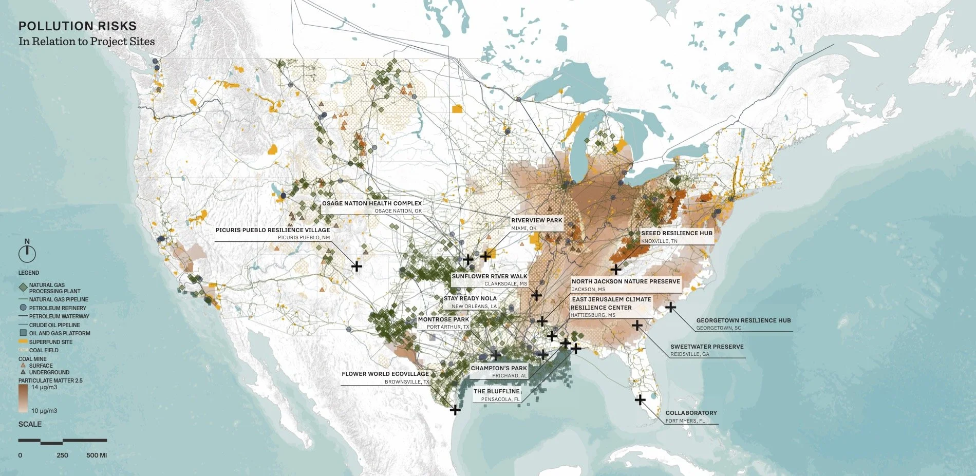
Pollution is at the Root of Environmental Injustices: Through the grant program, landscape architects were tasked with investigating regional and local pollution hazards to reduce pollution in communities.

Featured Community: Jackson, Mississippi: Shedding Light on Racial and Socio-Economic Disparities Undetected in Traditional Data: Storytelling illuminated social realities in North Jackson that census tract data did not accurately capture due to the vast wealth gap in this area.

Inaccessible Ecological Richness in Their Backyards: Site analysis revealed incredible beauty and diversity along the Pearl River that residents currently cannot access.

Uncovering Design Opportunities through Storytelling: Inspired by Dr. Crawford’s advocacy and informed by his input, the design incorporated accessibility as a foundational principle for the preserve.

Featured Community: Miami, Oklahoma: Addressing the Legacy of Mining Contamination and Flooding: Flooding caused by dam operators compounds the health risks associated with lead pollution. L.E.A.D. Agency conducts their own detailed flood mapping.

Finding Opportunities to Re-Envision a Flood-Prone Park in Decline: Flooding has led to the disinvestment of one of the city’s main parks. Many local voices highlighted the lack of safe access to nature.

A Place for Joy: Restoring Critical Access to Nature in Riverview Park: The park is reimagined as a space offering healing and reconnection with the land through ecological restoration and nature trails.

Featured Community: Hattiesburg, Mississippi: A Resilience Hub Before It Was Cool: Ms. Janet has spent decades serving elders and children in her community in the face of climate and social vulnerabilities.

Blood, Sweat and Tears: The OMYDC team have poured their time and resources into maintaining the building, so a climate-hardening renovation was the desired project strategy.

Building Local Capacity Through Partnerships: The detailed design proposals were informed by the many rich partnerships uniting around a clear desire to better serve their community.

Technical Assistance Process: Bridging the Gap Between Communities and Federal Grant Requirements– Storytelling supported all tasks. Narratives and portraits humanized climate challenges, strengthening the project proposals and grant applications.

Navigating Accelerated Engagement: As new communities applied for assistance, the team adjusted timelines to ensure project completion before the grant application deadline.

A Resource for Future Grant Applications: The final report provided documentation of all deliverables, leaving communities with detailed project plans to seek funding.

Shared Goals for Community Change: Across the 15 communities, the outcomes of the project go beyond the numbers calculated to determine the potential climate and pollution benefits.